© 2026 Grizzly Sport & Motorrad Resort GmbH
Designed and Built by www.chrisschnedl.comDreiländertour A-I-SLO
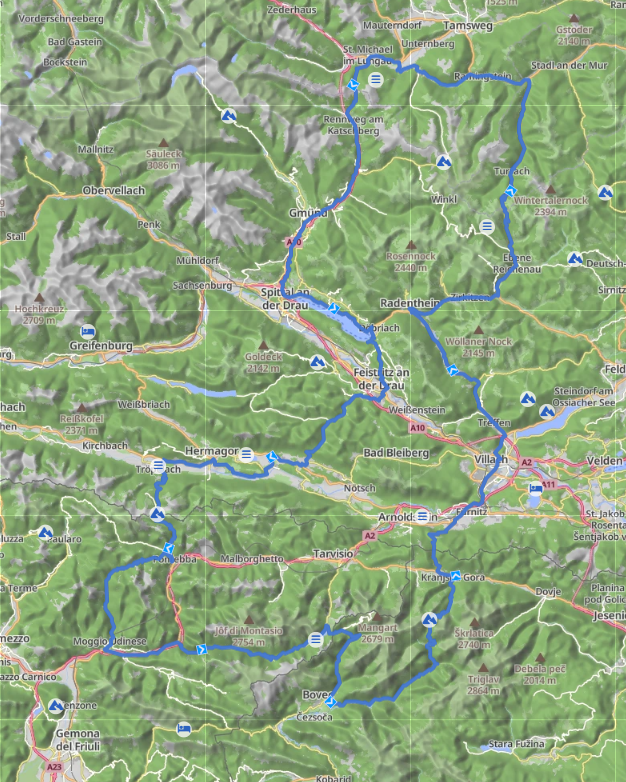
Tour
Dreiländertour A-I-SLO
- Total Length:
- 384km
- Duration:
- 7h
- Charge:
- Yes
- Places of Interest:
- Katschberg Höhe, Windische Höhe, Nassfeldpass, Sella Nevea, Predil Pass, Vrsic Pass, Wurzenpass, Turracher Höhe
Description of the tour
Grizzly – St. Michael – Katschberghöhe – Rennweg – Kremsbrücke – Eisentratten – Gmünd – Perau – Treffling – Seeboden – Dellach – Döbriach – Feistritz an der Drau – Pöllan – Kreuzen - Windische Höhe - Matschiedl - St. Stefan im Gailtail – Latschach - Dellach/Dole - Neudorf -Hermagor – Postran - Richtung Nassfeld Pass - Tröpolach – Nassfeldpass – Pontebba – Frazione Studena Alta (Aupa Tal) – Bevorchians – Dordolla – Grauzaria – Moggio Udinese – Resiutta - Chiusaforte – Pezzeit - Sella Nevea – Lago del Predil - Predil Pass - Strmec na Predelu – Kal-Koritnica - Podklanec – Soca (Socatal) – Trenta - Pri Cerkvi - Vrsic Pass – Kranjska Gora – Podkoren - Wurzenpass – Hart - Villach – Sankt Ruprecht bei Villach - Treffen – Äußere Einöde – Afritz am See – Feld am See – Radenthein – Bad Kleinkirchheim – Patergassen - Eben Reichenau – Turracher Höhe – Predlitz – Kendlbruck – Ramingstein – Madling – Thomatal – St. Margarethen - Grizzly
Additional information
Einkehrtipps: Gasthof zum Enzian (Windische Höhe), Albergo Ristorante Wulfenia da Livio (Nassfeldpass), Chalet al Lago (Lago del Predil)
GPS Export
Upload the tour to your Navi
Easily add the Map to your Navi by following the steps below. If the type of your Navi is not listed below, please contact us.
For all Smartphone users: you can view the map in Google Maps. Simply click the button below.
- Connect your navi with the computer
- Choose the Type of your navi
- Click the download link
- Choose your navi on the list with mounted drives
- Choose the right directory on your navi
Mit dem Download einer Tour erkläre ich mich damit einverstanden, dass der Anbieter in keinster Weise haftbar gemacht werden kann, für eventuell auftretende Schäden am Navi durch den Download der Tour. Ebenfalls wird für die Fahrt entlang der Tour keine Haftung für jede Art von Schäden und/oder Ereignisse übernommen. Der Fahrer ist für sein Fahrzeug und die Teilnahme am Strassenverkehr selbst verantwortlich.